We will be running a downwind course. Please bear in mind that the direction of race will be announced at the briefing on the Friday evening at Fort Augustus.
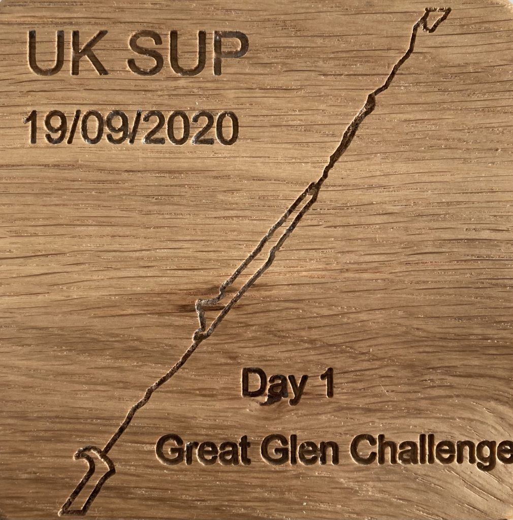
Assuming the wind is favourable, we will race from Fort William to Inverness. The information on these Great Glen Challenge pages will be emailed to entrants separately in advance of the event so you can plan and provision accordingly.
In theory it’s a straight line, so you should manage to find your way without any trouble. However, there are a couple of areas where you need to be paying attention so you don’t disappear down a river by mistake! We strongly recommend you take the time to recce the route online, with OS maps, Scottish Canal maps, etc. so you don’t get caught out by an unexpected portage or whatever.
It’s a fun evening of planning over a bottle of wine with your support crew so they know where they can park up to cheer you on as you go past.
for both the Two Day and Non Stop is:
Neptune’s Staircase, Banavie, Fort William
There is a pontoon to enable paddlers to enter the water easily. We ask that all paddlers are behind the start line prior to us releasing the first start.
The parking for the start has changed from previous years. It is shown on the map. We have changed to allow for more social distancing space when setting up. When we have released a start, the next start group will be allowed to leave the car park. Parking is now Banavie Locks Car Park. Parking is free and you can park overnight. No one will be allowed to drive into the car park we previously used.
We ask that noise is kept to a minimum for all starts, as this is a residential area.
Gairlochy Checkpoint
Please only portage as the route on the map shows. We will have marshalls directing the way. Please always follow their instructions.
Please use public parking and do not park on swing bridge or on bends of the narrow roads. As the bridge and road is accessed by trucks, who need room to manoeuvre. Parking is extremely limited.
Do not park illegally.
Laggan Checkpoint
Your second checkpoint will be at Laggan. This is approx. 27km after the start. At the end of Loch Lochy DO NOT portage onto the pontoon. This is private property. Follow the arrows that are on the map to our portage point. By portaging at this point you will cut over 100 metres off your walking distance. Anyone who portages onto the pontoon will receive a time penalty.
We will have a flag at the exit point for portaging. We will have food and snacks at this checkpoint. All support vehicles must approach this checkpoint via the A82 and use public parking. You will cross the lock bridge by foot to get to the checkpoint.
PLEASE do not park on private property.
Loch Oich
Loch Oich is the second Loch you will be paddling. This is the smallest Loch, at 6km long. This Loch is extremely protected from the wind and will probably be flat, even in high wind conditions. The road runs along the left hand side of this Loch, therefore that will be the safest side to paddle, if the unforeseen should happen and you require any assistance.
Fort Augustus Portage
Fort Augustus is the finish point of Day One and if you are going non-stop, this is the largest portage distance.
For the non-stop paddlers we will have water and snacks at this point.
Marshalls cannot assist with equipment at portages. The exit point is a pontoon on the left hand side. We will have marshalls at this point.
Race briefing for first start will be at 06:40.
For those doing non-stop you will be portaging through Fort Augustus and straight onto Loch Ness.
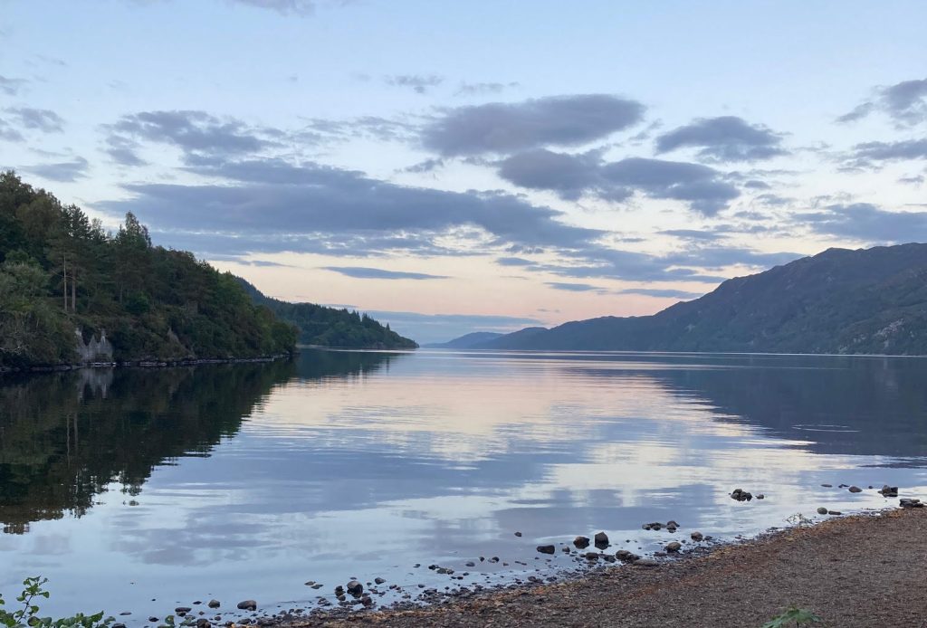
Be ready for Loch Ness: it is approx. 34km long and on a windy day it will be similar to the ocean. Make sure you have a craft you would feel stable on the ocean. Don’t let the flat calm at the start deceive you – conditions can change and build quickly on the Loch.
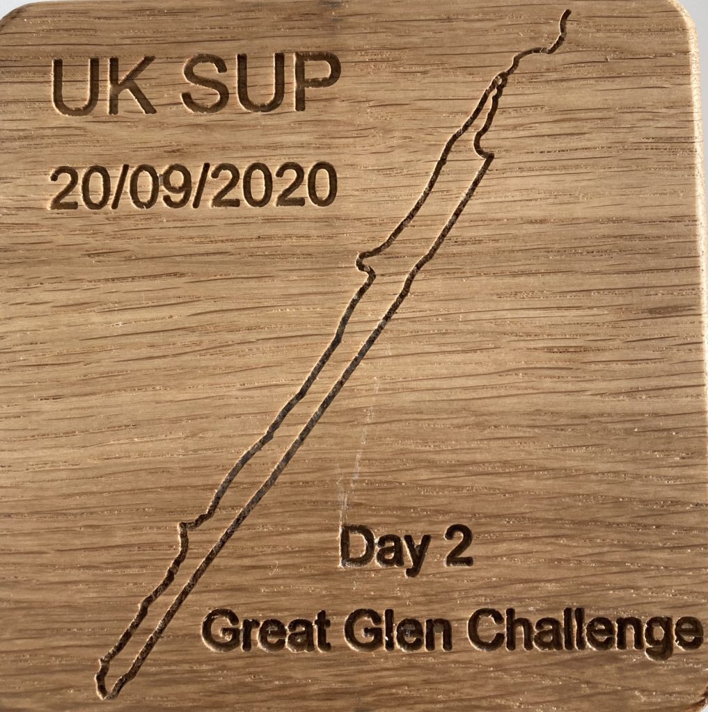
Loch Ness
Loch Ness is 34km long and in medium to high wind will be similar to the ocean.
There are four safe pull out points along the way. These are all marked on this map. Be aware you will have steep banks and rugged coastline most of the way. You will be travelling in the direction of the wind. If you find yourself tired, stop paddling and the wind will keep you moving. There are no checkpoints on Loch Ness. Please ensure you have enough food and hydration to keep you going. The road runs along the left hand side of the Loch, paddle on the left hand side.
Only enter Loch Ness if you are sure you feel comfortable with the conditions.
Dochgarroch Checkpoint
This is the final checkpoint before the finish. There is plenty of public parking at this checkpoint. There is a café at this checkpoint. We will have food and drink at this checkpoint for paddlers.
Great Glen Finish Point
The finish point of the Great Glen is Canal Road, Inverness. On approach to the finish point there is a pontoon on the right hand side. This pontoon is our finish line.
On completing the race, please clear the race course as quickly as possible and do not impede anyone who is finishing behind you.
There is plenty of parking and good access for paddlers, support and boards/boats.
Entry is through the Sailingfast Website either by clicking on these links, or searching for ‘Great Glen Challenge’
Great Glen Paddle 2024 – NON STOP ULTRA Friday 20th September
Proposed Dates for 2025: Friday 19th and Saturday 20th September
A competitors’ booklet will be emailed out prior to the event containing information such as checkpoint details, emergency procedures, etc.
The competitors’ briefing will take place in Fort Augustus on the Thursday evening.

View Map

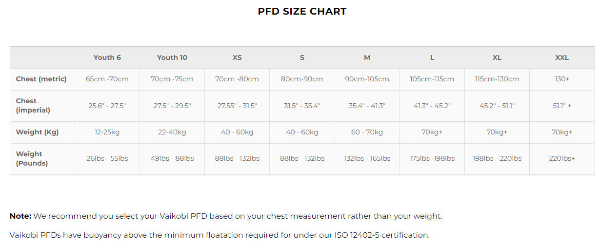
| XS | S | M | L | XL | XXL | |
|---|---|---|---|---|---|---|
| Chest (Centimeters) | 82cm -87cm | 89cm-95cm | 97cm-102cm | 107cm-112cm | 117cm-122cm | 127cm-132cm |
| Waist (Centimeters) | 66cm – 70cm | 71cm – 76cm | 77cm – 85cm | 86cm – 95cm | 96cm – 105cm | 106cm – 114cm |
| XS | S | M | L | XL | XXL | |
|---|---|---|---|---|---|---|
| Bust (Centimeters) | 78cm -84cm | 85cm-90cm | 91cm-97cm | 98cm-103cm | 104cm-109cm | 110cm-116cm |
| Waist (Centimeters) | 58cm – 69cm | 64cm – 70cm | 71cm – 76cm | 77cm – 83cm | 84cm – 90cm | 91cm – 97cm |
| Hips (Centimeters) | 82cm – 90cm | 90cm – 96cm | 97cm – 102cm | 103cm – 108cm | 109cm – 115cm | 116cm – 122cm |
| US Mens | 5 | 6 | 7 | 8 | 9 | 10 | 11 | 12 | 13 |
|---|---|---|---|---|---|---|---|---|---|
| UK Mens | 4.5 | 5.5 | 6 | 7 | 8 | 9 | 10 | 11 | 12 |
| EUR | 36.5 | 38.5 | 40 | 41 | 42.5 | 44 | 45 | 46 | 47.5 |
| Foot Length (cms) | 23.5 | 24 | 25 | 26 | 27 | 28 | 28.5 | 29 | 30 |
| Foot Length (inches) | 9.2″ | 9.4 | 9.8 | 10.2 | 10.6 | 11 | 11.2 | 11.4 | 11.8 |


